Mariela’s Field Notes: Monitoreo de Machuca
- Aug 11, 2021
- 3 min read
Updated: May 8, 2024
DUNAS team leader Mariela tells us about the monitoring work being carried out in the archeological site of Machuca near the dune restoration area.

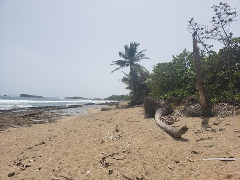
La restauración de las dunas que el proyecto DUNAS lleva a cabo se encuentra localizada dentro de la Hacienda la Esperanza en Manatí. Dentro de la hacienda se encuentra Machuca, sitio arqueológico indígena que está siendo afectado por el cambio climático como muchos otros lugares alrededor del archipiélago de Puerto Rico. Durante este mes de julio, por el paso cercano de ondas y sistemas atmosféricos, el lugar ha recibido marejadas, erosionando el lugar. El martes 13 de julio visite el área junto a mi colega, Zuleyka de Para la Naturaleza para ver el impacto del fuerte oleaje sobre el área. The restoration of the dunes that the DUNAS project is carrying out is located within the Hacienda La Esperanza in Manatí. Inside the hacienda is Machuca, an Indigenous archaeological site that is being affected by climate change like so many other places around the Puerto Rico archipelago. During this month of July, due to the nearby passage of atmospheric systems, the place has received tidal waves that have continued eroding the site. On Tuesday, July 13, my colleague Zuleyka from Para la Naturaleza and I visited the area to see the impacts of the strong wave action to the area.
Ese día visitamos los puntos que ella había identificado con material expuesto. Se tomaron puntos de GPS, notas descriptivas de cómo se veía el área y del material y se tomaron fotos, todo para mantener registro de cómo va impactándose el área. En poco tiempo se ha visto el impacto que no solo los huracanes tienen en el área, sino como el cambio climático y la subida del nivel del mar ponen en peligro el patrimonio cultural de Puerto Rico. That day we visited the points with exposed material that she had identified. We took GPS points, descriptive notes and photos to keep track of how the area is being impacted. In a short time, we have seen the impact not only hurricanes have on the area, but also how climate change and rising sea levels endanger Puerto Rico’s cultural heritage.
Proyectos como el de DUNAS, y otros proyectos comunitarios que están surgiendo para la restauración de diversos ecosistemas marinos son parte de la solución que nos dará un poco de tiempo para proteger áreas afectadas, en lo que se encuentran alternativas a los cambios que están ocurriendo en nuestras costas. Projects such as DUNAS and other community projects that are emerging for the restoration of various marine ecosystems are part of the solution which will give us a little more time to protect affected areas while alternatives are found to address the changes that are occurring on our shores.
Estas cuatro fotos muestran cómo se está erosionando la costa. El sedimento rojizo que se ve en las fotos forma parte del terreno que está asociado al lugar arqueológico. These four photos show how the coast is eroding. The reddish sediment seen in the photos is part of the terrain that is associated with the archeological site.


This project is made possible through a 2018 Climate Adaptation Fund grant from the Wildlife Conservation Society (WCS) entitled, “Puerto Rico se Levanta: Learning from extreme events to build and sustain a resilient future". Support to establish the Climate Adaptation Fund was provided by a grant to the WCS from the Doris Duke Charitable Foundation.


